Sunday, August 30, 2015

Changes

 
Life was pretty normal in Zambia until the end of June.  The previous rainy season was short and had not produced enough run off to fill Lake Kariba.  Kariba is the world's biggest man-made reservoir by volume that straddles the Zambian and Zimbabwean border and supplies about 1,830 megawatts of power to the two nations when running at full capacity.  The dam was 40 persent full on July 19, less than half what it was a year ago, according to official data.  Fed by the Zambezi river, the reservoir is 226 kilometers (140 miles) long and as wide as 40 kilometers. 


Flood gates on the Kariba Dam between Zimbabwe and Zambia.
 
The low volumn of water has caused the local utility company to do what they call "Load Shedding". Power production is reduced by restricting the flow of water from the reservoir through the hydro-electric plant.  This means that customers do not have power supplied to them for several hours each day. In our case we are without power (which also means no water) for about 8 hours every day. It is either out between around 8 a.m. to 4 p.m. or from around 2 p.m. to 10 p.m.  We were spoiled with electricity everyday all day until this happened.  We struggled along for a few weeks and then decided that we had better start looking for some alternatives.  It appears that the chances of changes in the situation will not get better until the end of the year when the rain comes again.
 
So we researched generators.  You have to feed them constantly so we didn't need that added burden and expense.  We wondered what an UPS (un-interupted power supply) would do and we located some that worked off the utility power source and some that worked off of solar. 
 
In the mean time we found some little solar powered lights.  One side is a solar panel and the other side is an LED light.  They work very well for about 4 hours on a full charge.
 
 
That was helpful when the power was out after dark but it still didn't provide power for the internet and computer operations that we needed during the day light hours.  The decision was made to purchase an electric charged UPS system with battery back-up.
 
 
We can now have the internet on demand when there is no power as the inverter turns the DC power stored in the battery to AC power.  It also allows us to run a fan, lights and computer chargers.  Talk about being spoiled again.  Except there still is no water when the power is off as the pump and similar items with over 1000 watt needs will not work.  Water continues to be stored in empty 2 liter milk bottles so we can have cold water to wash or clean with. 
 
The other change came more suddenly this week.  We received a call from the Mission President on Wednesday to talk about our assingment to the Matero Ward, where we have been attending since arriving in Zambia.  In his monthly Interview with the Stake President they discuss missionary assignments to the Stake.  They counselled about some development of the Priesthood in the stake and concluded to change our assignment from the Matero Ward to the Lusaka Ward.  We are not sure what exactly we will be doing but the new couple (Elder and Sister Groesbeck) who arrived a week ago will fill in at the Matero Ward.  They will be great.  We will miss our friends in Matero.
 
This is Bishop Chifunda with his counselors and Ward Clerk.
 
 
From left to right: Brother Sakala, Ward Clerk; Brother Bwalya, 1st Counselor (he has been ill); Bishop Chifunda; Brother Kalonga, 2nd Counselor; Sister and Elder Bodily


Sunday, July 19, 2015

Siting for Boreholes at Mulenje

This past week and a half we took 3 trips into the Mulenje Community doing a survey of the areas we would like to do boreholes.  The survey process is called "Siting" and it involves looking for a likely spot and then setting up a resistivity instrument and taking reading of the resistance to electrical currents in the earth.  A probe is driven into the ground each side of the instrument at about 7 meters from the instrument.  The probe is connected to a wire that comes from the instrument and a charge is sent into the earth through the probe.  It returns thru the other probe and the reading is recorded.  The probes are then moved a few meters further away and another reading is recorded.  This happens repeatedly until the probes are each 100 meters from the instrument.  This data is then entered into a computer program and it gives a graph that shows how deep the possible water is in the earth.  Water conducts electricity so there is little resistance to the electrical current when it passes thru water as compared to the resistance when the current passes thru earth or rock. 

         Here is the resistivity instrument.  You can see the wires leading away from the instrument.

 
Here is Darius Banda recording the readings.  He works for the Department of Water Affairs and has been taking these readings for 20 years.  In the background, directly above the instrument, you can see the probe and the spool of wire (yellow object) that is connected to the instrument.
 
 
When we were last in Mulenje we had taken several readings with our GPS instrument so that we could locate the community on Google Earth.  We plotted the points on Google Earth and then zoomed in over the community to see where people were living.  There were several locations in the 28 square kilometers where the people were more concentrated.  On Google Earth we located those areas where we thought a borehole would serve a maximum number of people and then we took the coordinate readings of those areas so we could drive close to them in the bush.  When we went back to Mulenje we drove to the areas with the help of a native guide and then relied on Darius to pick the places to take the readings.  At each area we took two readings so that we could pick the best placement for a borehole. 
 
Our first stop was Mulenje Community School.  They had made improvements in the school by paining and install glass in the windows.  This gave us hope that they would be sure to take care of the borehole since they are improving the school.  You might remember a previous blog that had a picture of this room and the wall was the blackboard.
 
 
The siting here was done at an ant hill.  The ants are supposed to be good at detecting the underground water.  This is a small ant hill compared to many.  The stake in the foreground is where the siting was done.  We record the locations with our GPS device.
 
 
On our next trip we visited two locations on the east side of the community.  We forgot our maps and coordinate information so we had to rely on our study of the area on Google Earth and The Spirit to give us direction.  When we attempted to go to our first desired area we found that there was already a borehole constructed there that we had not been told about, so we drove in another direction to find others who were not being served with clean water. 
 
Here is the existing borehole.  It is constructed very nicely.
 
 
The second location was to the north and located near to where the assistant headman lives.  He showed us where they are currently getting some of their water.
 
 
While there we also took a look into his year's supply stored in this enclosure.
 
 
This is their staple food, white maize.  They mill this and then make the nshima which they eat almost every meal.  If they don't eat it then they feel like they haven't eaten.
 
 
On our third trip we went to an area in the middle of the community.  We were impressed with the neatness of their buildings.  Check out the paint job.
 
 
We did two sitings here, and while Sister Bodily was waiting some young boys convinced her to try some wild fruit.   Elder Bodily did not need to try it after Sister Bodily described the taste.
 
 
We then headed to the Southwest corner of the community.  We knew where we wanted to end up but our guide kept on taking us to where he wanted to go.  With out maps and GPS device we finally convinced him that we knew where we wanted to be.   After circling around where we wanted to be on roads and trails in the bush, we were successful in arriving at our desired location.
 
Here we find ourselves at another ant hill.  However, Darius thought our second siting in this area was better even though it was in some thick brush.


Some boys had skipped school that day, so they along with some men were watching what we were doing.  They are always interested when you are considering bringing them some clean water.  This 12 year old boy was always close so we had him help pick up the equipment when we were finished.  He seemed pleased to be included.
 
 
Now we wait for the results of the survey.


Wednesday, June 17, 2015

Mosi-oa-Tunya National Park

Zambia has a small National Park on the outskirts of Livingstone.  It carries the same name as the native name for Victoria Falls, Mosi-oa-Tunya.  It has a variety of animals but none are preditors except man so the animals here are pretty safe.  One of the attractions at this park are the White Rhinos (The name is derived from their wide mouth not their color.  At some point instead of saying wide it got changed to white.)  We scheduled an event that they call Rhino Walk.  So off we went to see the Rhinos.  We left Chanters Lodge in an interesting old Toyota pickup with our guide, Arnold, and Robert the driver.  We entered the park and drove until we picked up our armed guard who would guide us to where the Rhinos would be found.  They are guarded 24 hours a day and 7 days a week as there is so much poaching in Africa for Rhino horns and Elephant tusks.

While driving to pick up the guard we came across this Waterbuck.  The pictue does not show the description that the guide gave us of the back end of this animal.  He said it looks like a white toilet seat that provides identifcation of whom to follow when they are running from preditors.
 
 
When we stopped to "pick" the guard we moved to the back of the truck so we could better view the animals.
 
 
After driving a short distance we  parked the truck and headed through the brush with strict instructions to follow closely behing our guides and follow their footsteps for our safety.
 
 
Our first encounter was with the zebras.  They were shy.  Their stripes are identification like fingerprints are for us.  The young quickly memorize their mother's stripe pattern.
 
 
We wandered around for awhile being taught which animal had left their dung and whether the animal was male or female, alone or in a group.  Aronold also taught us about the various trees and shrubs and their uses by both natives and animals. Some of the trees even have a defense mechanism to prevent the animals from eating all of their leaves.
 
 
Then we quietly came upon three, female rhinos and two male calves. 
 
 
The bigger baby was an orphan that the mother of the younger calf  had adopted and was nursing with her own calf.  Female rhinos are picky about their mate and will not conceive with a dominate male she is not in love with.  The dominate male, and father of the younger calf, recently died.  So far these females have not accepted the new dominate male. 
 
 
Their poor eyesight mades it possible to get pretty close. Their hearing is very good and they follow the sound of footsteps, so we were cautioned to not move quickly or loudly.
 
 
Arnold had brought scones (biscuits), muffins and drinks for a picnic lunch close to the Zambesi River.....but not too close as crocodiles were known to be very plentiful near the water.  The bird is the pied king fisher.
 
 
After lunch Arnold went out of his way to make sure we saw giraffes. We were fortunate to get such a close up view of them.
 
 
Earlier we had seen a bachelor herd, but they were far away.  This group were females with a calf. 
Females grow hair on the top of their horns, the males do not.
 
 
Before leaving the park we passed a herd of cape buffalo and more zebras.  These animals co-exist very comfortably together.  We thank Arnold and Robert for such an enjoyable morning adventure.


Tuesday, June 16, 2015

Chobe National Park

There was another want to see activity as part of our service in Zambia.  That was to visit a National Park and observe the flora and fauna of Africa.  This past week while we were in Livingstone we were able to accomplish that goal as there are two National Parks close to Livingstone.  One is Chobe National Park just across the border from Zambia in Botswana.  Chobe offered a one day trip that gave us the morning on the Chobe River and the afternoon in the bush along the banks of the river.  The guides on both parts of the experience were excellent at relating interesting information about the plants, birds and animals of the areas we traveled. 

Our ride in the morning was in this boat and as you can see it was almost a private tour.
 
 
Our first encounters on the water was with several species of birds. This cute little couple of wire-tailed swallows put on a show for us and kept resting on the bow of the boat then flying around and landing back on the boat to see if we caught their show. 
 
 
This is an African darter (sometimes called the snake bird) that we shot a picture of before he darted into the water.  They spread their wings out after surfacing to dry them so they can fly.
 
 
The African fish eagle is probably the most familiar bird of prey in Africa.  We saw at least four of them flying around and in nests high in the trees along the river bank. We heard a male and female calling to each other.  His is a high voice, hers is lower
 
.
This lovely little fellow is the white fronted bee-eater.  It builds nests in small holes in the dirt banks.  If the hole was enlarged it was because monitor lizzards raid the nests.
 
 
And if you don't believe us, here comes the monitor lizzard.
 
 
This big crocodile was sunning himself because he is cold blooded.  He is also blood thirsty.  We stayed in the boat!  Please note how he has one eye opened and is watching us.
 
 
At first we could only see hippos in the distance.  Then they all of a sudden appeared in abundance.
 
 
This hippo is a male because he is away from the pod and has scars on his body from trying to fight his way to dominance over the dominate male.  Typical behavior in male African animals.
 
 
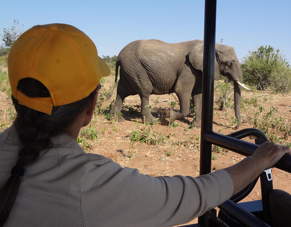
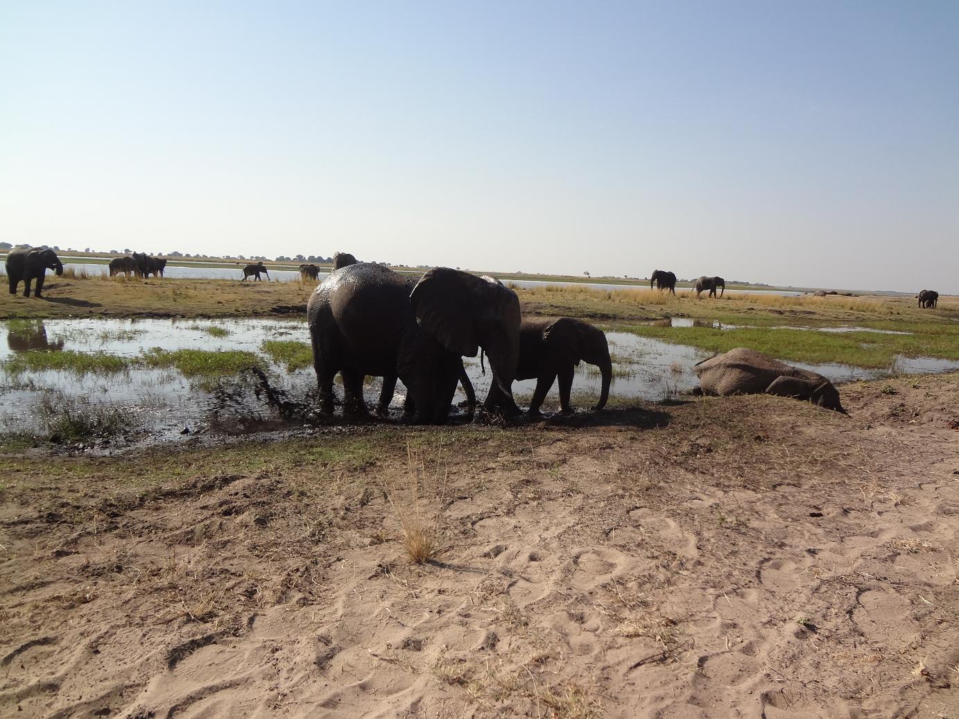
The elephants were coming down for water.  They can go 3 or 4 days without drinking.  We were amazed by the number of elephants that kept coming.  An older female leads the younger females and young elephants.  The mature males stay in separate bachelor herds.
 
 
After a delicious buffet lunch at the Chobe Safari Lodge we took a jeep ride and experienced many more elephants on land.
 
  
This is an elephant digging a mud spa. They splashed, rolled, slipped, crawled and had a wonderful time of it.  Some even swam across the river to the Island.  All you could see was the tip of their trunk when the water got too deep for them to walk.
 
 
What the elephant leaves behind, the baboon picks through for hidden treasures.  Elephants have a poor digestive system and so the nuts they eat from the trees are intact for the baboons to feast on.
 
 
These guys belong to group that is known as "The Ugly Five."  It is a funeral of Marabou storks.
 
 
Impalas have these markings on their behinds so they can recognize and follow each other in a chase.
 
 
You hunters might salivate over this big, Kudu buck.  His stripes on his back are light and faded which indicates he is old.  That might also be why he is alone. 
 
 
Here is another member of  "The Ugly Five". This warthog is just chilling in the shade.
 
 
We took a break and got out of our jeep to stretch and releave ouselves before heading back to the boarder.


Monday, June 15, 2015

One of the 7 Natural Wonders of the World

Victoria Falls has been on our want to see list since arriving in Zambia.  The opportunity to go there presented itself  when our friends, Mike and Nancy Fisk from Malawi, completed their mission and needed a ride to Livingstone where they were to meet friends from the states.  "Victoria Falls is locally known as Mosi-oa-Tunya which literally means the Smoke that Thunders.  David Livinstone, The Scottish missionary and explorer, is believed to have been the first European to view the falls in 1855....He gave the falls the name 'Victoria Falls' in honour of his queen."
 
Nearing the Falls it is easily understood why the local people call it "The Smoke that Thunders."  You could see the mist and hear the thunder.
 
 
The river at the falls is 5,604 feet wide and 360 feet tall so it is impossible to see it all at once.  Maximum flow is 3,000 cubic meters/second. 
 
 
This is just a small portion of the falls.  It was amazing to realize there was this much water flowing over it for a much longer distance than we could see.
 
 
There is a constant mist rising from the water as it drops the 360 feet into the narrow gorge below.  A view on Google Earth will give you an idea of the width of the gorge.
 
 
There is a bridge called "Knife Edge" that we crossed over to what is called an Island, but is more like a peninsula.  We wore ponchos, but still managed to get plenty wet.  It was like a heavy rain that ran in streams on the trail in some places. (If you get your feet wet you will be miserable the rest of the day.)
 
 
When you get to the end of the Knife Edge trail you get a view of Zimbabwe.  The falls are all in Zambia but to see the rest of the falls you need to go to Zim.
 
 
This is the bridge some people bungee jump from and is also the way to Zimbabwe. 
 
 
This is the mostly dry part of us after our walk on the misty trail.
 
 
This little guy took one look at me as if to say, "Grandma!"and came running straight towards me.
 
 
Later in the day Papa was found relaxing with his friends the guinea hens.